
|
Nature is very kind to Chhattisgarh in terms of rainfall as compared to several other states of the Union. Average rainfall in the state is around 1400 mm. and about 90% of the total rainfall is confined in the Monsoon season i.e. 15th June to September. The rainfall has erratic temporal and spatial distribution in the state. Due to this variation in the rainfall, the agriculture production of the state, which is mainly Paddy, is affected. In fact; every third year, there is always a threat of drought, which is due to uneven occurrence of rainfall rather than deficient rain. It is obvious that irrigation is the prime need of the state.
|
||||||||||||||||||||||||||||||||||||||||||||||||||||||||||||||||||||||||||||||||||||||||||||||||||||||||||||||||||||||||||||||||||||||||||||||||||||||||||||||||||||||||||||||||||||||||||||||||||||||||||||||||||||||||||||||||||||||||||||||||||||||||||||||||||||||||
|
||||||||||||||||||||||||||||||||||||||||||||||||||||||||||||||||||||||||||||||||||||||||||||||||||||||||||||||||||||||||||||||||||||||||||||||||||||||||||||||||||||||||||||||||||||||||||||||||||||||||||||||||||||||||||||||||||||||||||||||||||||||||||||||||||||||||
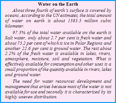
| Estimated surface water flowing through rivers is 48,296 Million Cum. and due to various geographical and interstate constraints the usable surface water in the state is 41,720 Million Cum. Surface water being used at present is only about 18,249 Million Cum. Estimated ground-water in the state is 14,548 Million Cubic meters and present exploration is about 18.31%. A comprehensive master plan for the state, for optimum use of water resources is under preparation. The state is moving ahead towards a more integrated and sustainable approach to water resources management. |
||||||||||||||||||||||||||||||||||||||||||||||||||||||||||||||||||||||||||||||||||||||||||||||||||||||||||||||||||||||||||||||||||||||||||||||||||||||||||||||||||||||||||||||||||||||||||||||||||||||||||||||||||||||||||||||||||||||||||||||||||||||||||||||||||||||||


 a lifeline to the socio-economic development of the state. Most of the rivers in the state have a torrential regime characterized by high flow of water for three to four months during monsoon (June to September) during which around 80% of the annual runoff flows. Floods and droughts are the main characteristics of the annual flow of the rivers in Chhattisgarh requiring storage reservoirs for efficient use of the available surface water resources.


